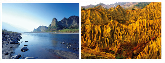
Left : The Eighteen Arhat Mountains / Right : “Moon World” badland terrain
|
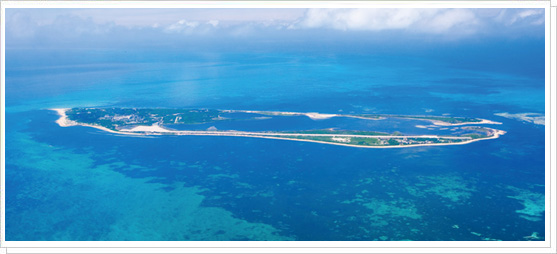
Dongsha Islands
|
Kaohsiung City has a land area of 2,946 square kilometers, just over half of which is high mountains. Kaohsiung’s mountains and forests represent excellent tourism resources. From the city’s mountains and rivers to its waterfronts and seacoast, Kaohsiung’s mountain and ocean scenery is rich and varied, and has a high touristic and economic value.
Most of Kaohsiung’s mountain ranges are located in the east and northeast of the city. The southern part of the Yushan Range extends into Taoyuan, Namasia and Jiasian Districts, and the 3,844-meter-tall Yushan South Peak lies within Kaohsiung’s city limits. To its east are other high peaks such as Guanshan and Siaoguanshan. Next to the coast, close to the main urban area, are Shoushan and the smaller Banpingshan. Shoushan is a famous tourist attraction, with ancient monuments, scenic beauty and a rich natural ecology. It is one of southern Taiwan’s major beauty spots.
Besides the mountains and forests, in Tianliao District there is a famous area of limestone badlands, with undulating hills, criss-crossing river valleys, and sharp ridges shaped by long scouring. Hardly a blade of grass grows here. Known as “Moon World” because of its similarity to a moonscape, this terrain has a haunting, desolate beauty.
The main rivers within Kaohsiung’s city boundaries include the Gaoping River, the Cianjhen River, the Love River, the Dianbao River, and the Agongdian River. Of these, the Gaoping River has the largest watershed area of any river in Taiwan, and drains much of Kaohsiung City’s territory. Flowing into the sea in Linyuan District, it is one of the Kaohsiung’s main water sources for agriculture, industry, and household use. Its main tributaries are the Nanzihsian and Cishan Rivers. The Love River runs right through upscale areas of central Kaohsiung. The areas along its banks combine natural and cultural landscapes, and have developed into one of Taiwan’s best-known urban waterfront beauty spots. To the north there is also the Erren River, which for the lower part of its course marks the border between Kaohsiung and neighboring Tainan City. Following highly successful ecological rehabilitation efforts in recent years, the Erren River offers a rich wetlands landscape.
Chengcing Lake in Niaosong District and the Lotus Pond to the southwest of Banpingshan are both popular recreational sites, and two of the best-known places in the city. While most of Kaohsiung’s land area is on the main island of Taiwan, the city’s territory also encompasses Cijin Island, a major center of leisure fishing and tourism, which forms the natural barrier between the Port of Kaohsiung and the Taiwan Strait. Beyond Cijin Island, the jurisdiction of Cijin District also extends far out into the South China Sea to the Dongsha (Pratas) Islands and to Taiping Island and Jhongjhou Reef in the Nansha (Spratly) Islands. |
| Data source: Urban Development Bureau, Kaohsiung City Government |
|